The Day the Ground Moved for Four Minutes: Anchorage and the 1964 Earthquake
The magnitude 9.2 Good Friday earthquake remains the largest ever recorded in North America. Sixty-two years on, its lessons are built into every Anchorage code book — and its ground is still visible from the Coastal Trail.
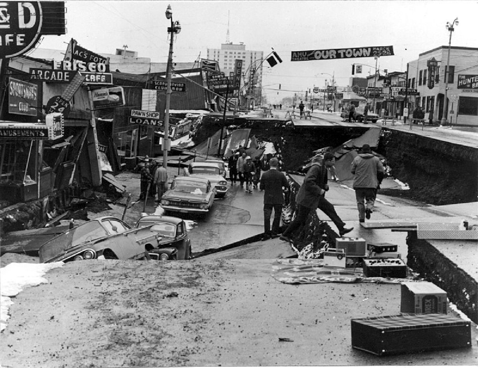
At 5:36 p.m. on Good Friday, March 27, 1964, the ground under southcentral Alaska began to move — and kept moving for roughly four and a half minutes, an eternity in seismic time. The magnitude 9.2 earthquake centered in Prince William Sound remains the most powerful ever recorded in North America and the second-largest in recorded history worldwide.
Anchorage, 75 miles from the epicenter, was torn by its own geology. The bluffs along the northern edge of downtown — built on a sensitive marine clay known as the Bootlegger Cove Formation — failed and slid. The Turnagain neighborhood slid into the inlet in a slow-motion collapse of houses and streets. Downtown's 4th Avenue dropped in a graben, storefronts sank below street level, and the control tower at Anchorage's airport collapsed. Schools cracked and split; one, Government Hill Elementary, broke apart atop a slide. In all, the quake and its tsunamis killed 139 people across Alaska and the West Coast.
The earthquake rewrote the city's relationship with its ground. Anchorage rebuilt with new seismic building standards informed by the disaster; the geology of the Bootlegger Cove clay has been mapped, zoned and engineered around ever since. The slumped, ghostly terrain of Earthquake Park along the Coastal Trail is the slide zone itself, preserved as the city's open-air memorial and geology lesson.
The scientific legacy is equally large: the 1964 quake proved the theory of plate tectonics in a single event — the Pacific Plate had thrust beneath Alaska, uplifting some areas by more than 30 feet and dropping others — and it led directly to the modern tsunami warning system and to seismic monitoring networks across Alaska today.
For Anchorage, the history is not abstract. It is the reason for the building codes, the port's seismic anxieties, and the drills in every school. When the magnitude 7.0 quake struck in November 2018, the city responded the way it did because 1964 taught it how. Remembering the big one is not nostalgia here. It is maintenance.